| The Black-Farewell and Maple Grove
Wetlands, which contain numerous species at risk, are being threatened
by both residential development as well as a link between Highways 407
and 401.
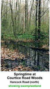
The provincially significant Black-Farewell and Maple Grove Wetland
complexes, covering 734.4 ha, are in the Municipality of Clarington
near Courtice and the hamlet of Maple Grove (in the Durham Region).
They are noteworthy for supporting the largest wetland
complexes in the GTA.
These areas contain part of the .07% of old growth forest remaining
in Ontario , among them a slowly disappearing hemlock. These complexes
sustain a high diversity of 59 wetland types, which explains the
hundreds of species of flora and fauna located there. Many of these
species are at risk, such as the Wood-Poppy, the Dense Blazing Star,
the Green Dragon and the Red-Shouldered Hawk. The wetland complexes
also form the headwaters of cold stream creeks, such as Black,
Farewell, Tooley, Darlington and Brookhill. The entire watershed is
located on a surficial aquifer, 2-10 m deep, underlain by clay. |
 |
These environmentally sensitive lands are close to urbanized centres
and there is a threat that they will be buried by residential
development. The area is also under threat from a proposed link
between Highways 407 and 401. The link would run through the core of
four provincially significant wetlands and woodlots of old forest
growth, bisecting the water basin that serves as a significant
groundwater recharge and discharge for connecting creeks and streams.
It is critical that these wetlands be preserved.
Old growth forests and species at risk must be protected, and flora
and fauna habitats must be maintained. Protecting these wetland
complexes is crucial for ensuring clean and substantial amounts of
drinking water, for sustaining a natural buffer zone and filtration
system for pollution and noise, and for preventing heavy rainfall and
floods.
[ Home ] [ Site Map ] [ Who We Are ] [ Black-Farewell ] [ Black Creek 2001 ] [ Local Wetlands ] [ What is a Wetland ] [ Our Watershed ] [ Map Links ] [ Current Events ] [ Studies ] [ MOEE Tips ] [ Photo Gallery ] [ Lake Iroquois ] [ Responsibility ] [ Govt. Contacts ] [ Enviro Links ] [ Message Forum ] |