What is a Wetland


Home
Site Map
Who We Are
Black-Farewell
Black Creek 2001
Local Wetlands
What is a Wetland
Our Watershed
Map Links
Current Events
Studies
MOEE Tips
Photo Gallery
Lake Iroquois
Responsibility
Govt. Contacts
Enviro Links
Message Forum

Last updated
24 August 2012


Wetland can be defined as an area of land which is
covered by water for part or all of the year.

springSwamp.jpg (11307 bytes)

There are four types of wetlands:
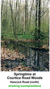
SWAMP

  • Characterized by flooded trees

  • May dry out each summer

  • Support woody plant life

  • Characterized by trees such as maple, ash, cedar

    (Courtice North Wetland Complex)


    MARSH

  • Most productive for wildlife

  • Have mixture of diverse emergent plants and open water

  • Contains cattails, bulrush, sedges, arrowhead, duckweed, wild iris, water  lily    (Oshawa Second Marsh)


  BOG

  • Found mostly in the North

  • Soil mainly peat(decomposed plants) making this type unique

  • Tends to have poor drainage (no outflow)

  • Low oxygen: acidic

  • Very old

  • Vegetation include sphagnum moss, cotton grasses, pitcher plants, sedges and black spruce     (Solina Bog)


  FEN

  • Similar to a bog with better drainage

  • Lower acidity, more plant life

  • Most common in Northern areas

  • Plants includelow shrubs, sedges, grasses, pitcher plant, sundew

  • Low oxygen: alkaline


WHY ARE WETLANDS IMPORTANT?

  • act as nature's water filtration and pollution system. Wetlands are capable of filtering pollutants such as chemicals and nutrients from water destined for our lakes, streams and our drinking water.  

  • offer numerous recreational opportunities such as fishing, hunting, wildlife viewing, canoeing and nature photography are one of the most diverse and productive ecosystems; they are home to over 600 species of birds, mammals, fish and plant life, many of which are rare or threatened

  • slow the overland flow of water, reducing the amount of soil sediment entering our streams and lakes
  • can reduce flooding by acting like giant sponges to absorb excess water and releasing it slowly; this storage of water also allows water to evaporate or to seep into the ground, replenishing the water table.


Wetland Map

Home ] Site Map ] Who We Are ] Black-Farewell ] Black Creek 2001 ] Local Wetlands ] [ What is a Wetland ] Our Watershed ] Map Links ] Current Events ] Studies ] MOEE Tips ] Photo Gallery ] Lake Iroquois ] Responsibility ] Govt. Contacts ] Enviro Links ] Message Forum ]