|
Oshawa/Courtice, Ontario
HARMONY CREEK WATERSHED &
FAREWELL - BLACK CREEK WATERSHED
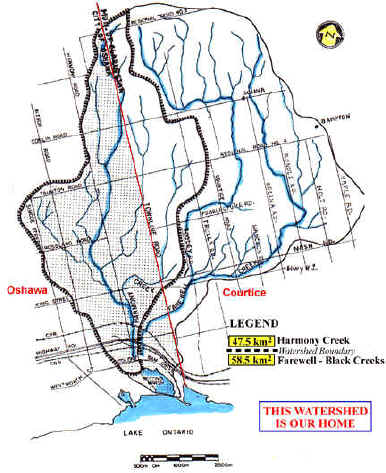
WHAT IS A WATERSHED?
A watershed is an area drained by a river or
stream. In our case, it is the Farewell Creek with its two main tributaries, Harmony and
Black; each stream is fed by many smaller streams which regulate temperature in creeks;
finally, these creeks feed Second Marsh in Oshawa and Lake Ontario.
PROBLEMS CAUSED BY OUR ACTIONS:
Almost anything we pour into our drain, each
flush of our toilet, pesticizers/fertilizers we use, even our car leak, etc. seeps into
the soil to our groundwater or it gets directly into the stream and finally it will end up
in Lake Ontario, our source of drinking water. Paving, storm runoff, stream diversions,
plowing under smaller streams and building on top of them, building on aquifers or too
close to the streams, removing vegetation along streams, etc. all have negative impacts on
water in our streams; the results of the above actions include aquifer contamination,
deteriorating water quality, raising water temperature, loss of fish, soil erosion and
flooding. Latest flooding in Manitoba, Quebec, Europe and
other places are just results of all the above activities.
WHAT MORE YOU SHOULD KNOW ABOUT
OUR WATERSHED:
Farewell, Black and Harmony Creeks rise well
below our regional groundwater recharge at Oak Ridges Moraine. The area around Taunton up
to highway No. 2 possesses a high water table and/or is underlain by sandy and gravelly
soils which serve as significant recharge area. Both the high water table and recharge
areas are important for the maintenance of baseflows in Harmony, Farewell and Black
Creeks. A significant portion of the original recharge area has been developed. In spite
of that the baseflow in all streams was reduced, the temperature is rising and more
sediment and pollution is entering these streams. There are plans to reduce or completely
eliminate this area.
This area is important not only for the
sustaining of these cold water creeks and Second Marsh in Oshawa, but also to us because
they drain into Lake Ontario - our source of drinking water. A study done for the Region
in 1994 states that: "This development represents a significant loss in the supply of
clean water to these streams. The remnant woodlots is what remains of a once extensive
forested tract that connected the Farewell and Bowmanville watersheds. These significant
woodlots controlled streamflow and water temperature".
They are: Harmony Conservation Area, Trulls Road Woods and Courtice Woods and Provincially
Significant Black/Farewell Wetland Complex. All of them now except Harmony are under
threat by approved additional development. Our government is not yet aware of what they
are approving and how they are going to affect our health in the future.
Glossary for our web pages (more may
be added later on) :
- Aquifers: Any water-bearing soil or rock formation that is capable of
yielding sufficient water for streams or human use for wells.
- Groundwater: Slowly moving water found underground in porous rock
supplying our streams and lakes.
- Recharge: The replenishment of groundwater by infiltration or seepage
from precipitation or surface runoff.
[ Home ] [ Site Map ] [ Who We Are ] [ Black-Farewell ] [ Black Creek 2001 ] [ Local Wetlands ] [ What is a Wetland ] [ Our Watershed ] [ Map Links ] [ Current Events ] [ Studies ] [ MOEE Tips ] [ Photo Gallery ] [ Lake Iroquois ] [ Responsibility ] [ Govt. Contacts ] [ Enviro Links ] [ Message Forum ]
|