|
COURTICE (northeast) URBAN BOUNDARY 1995
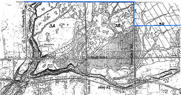
3a - heavily developed on seepage zones, covered-up
streams,…
3b - partially developed- tributary downstream was
cover by gravel and soil, natural water flow was redirected- additional forest removal is
planned
3c - is heading for approval and OMB hearing
Nothing on lands north of this boundary is known.
Waterhed study is required.
**There is no valid or sufficient information
available for areas north of the boundary (in blue). (See Studies
page)
Back to
Map Links
[Home] [Site Map] [Who We Are] [Black-Farewell] [Black Creek 2001] [Local Wetlands] [What is a Wetland] [Our Watershed] [Map Links] [Current Events] [Studies] [MOEE Tips] [Photo Gallery] [Lake Iroquois] [Responsibility] [Govt. Contacts] [Enviro Links] [Message Forum]
|