|
|
|
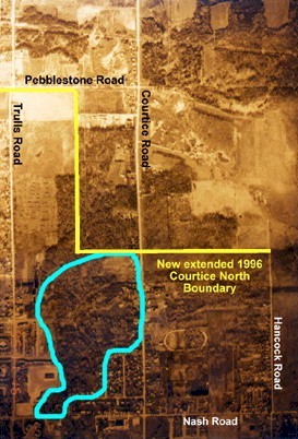
Birchdale Development (approved) Trulls Road Woods...
As you can see from the aerial photograph, most of the remaining forest (what's left of it after previous clear-cutting by developers in anticipation of re-zoning for development) is planned to be removed (see Studies and comments by agencies on the importance of this woodlot) for this new development. The development application area is circled in blue, and you can see it is almost completely covered (presently, but not for long) by a large section of Trulls Road Woods. If you are concerned about this, see our "Contact page" for information on how to make your concerns heard. "Blackcreek Developments Ltd. has submitted applications to permit residential development on the lands (shown in the Birchdale photo above). The proposed development is located partially within and adjacent to the Trulls Road Woods and the Lake Iroquois Beach formation. As well, a tributary of the Black Creek runs through the site." (Has now been approved) Dumping (contaminated) soil in Courtice
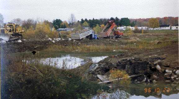
This photo shows dumping* of some of the 14,390 tonnes of soil from the old GM plant (Mary Street in Oshawa) in Clarington (Courtice). Dumping took place in 1996, after allowable soil contamination levels were lowered, but the 1989 guidelines applied to the GM site. The 1989 levels of contamination allowed were much higher than the 1996 new guidelines allow, but development can now take place on this land with the contaminated fill at the higher levels (1989). Would this worry you if you were buying a house here? Most contaminants will eventually dissolve and polute the groundwater for our wells, streams and lakes - source of our municipal drinking water. This site contains 11 times higher (than what is allowed by MOEE guidelines) amount of DDD; 10 times higher amount of DDE; 8 times higher amount of DDT; according to the computation sheet from the City of Oshawa the soil contains a higher amount of lead than 1996 guidelines allow. Is our Council satisfied with these levels of contamination at the site? *Dumping was not carried out by General Motors Contaminated soil - contact Clarington Council-623-3379
|